


VTD - Reeds precinct, Lawrence County, South Dakota
About
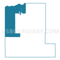
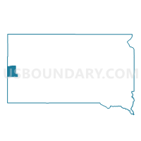
Outline

Summary
| Unique Area Identifier | 667456 |
| Name | VTD - Reeds precinct |
| County | Lawrence County |
| State | South Dakota |
| Area (square miles) | 143.94 |
| Land Area (square miles) | 143.78 |
| Water Area (square miles) | 0.15 |
| % of Land Area | 99.89 |
| % of Water Area | 0.11 |
| Latitude of the Internal Point | 44.48103510 |
| Longtitude of the Internal Point | -103.97934570 |
Maps

Graphs
Select a template below for downloading or customizing gragh for VTD - Reeds precinct, Lawrence County, South Dakota


Neighbors
Neighoring Voting District (by Name) Neighboring Voting District on the Map
- BEULAH Voting District, Crook County, WY
- SUNDANCE OUTSIDE Voting District, Crook County, WY
- VTD - precinct 16 Minnesela, Butte County, SD
- VTD - precinct 17 Fruitdale, Butte County, SD
- VTD - precinct 17P, Butte County, SD
- VTD - Spearfish city ward 1, Lawrence County, SD
- VTD - Spearfish city ward 2, Lawrence County, SD
- VTD - Spearfish city ward 3, Lawrence County, SD
- VTD - St Onge precinct, Lawrence County, SD
- VTD - Valley 2 precinct, Lawrence County, SD
- VTD- Rural 1 precinct, Lawrence County, SD
Top 10 Neighboring County Subdivision (by Population) Neighboring County Subdivision on the Map
- Spearfish city, Lawrence County, SD (10,494)
- North Lawrence UT, Lawrence County, SD (5,792)
- West Butte UT, Butte County, SD (2,686)
- Sundance CCD, Crook County, WY (2,602)
- South Lawrence UT, Lawrence County, SD (2,017)
- St. Onge township, Lawrence County, SD (339)
Top 10 Neighboring Place (by Population) Neighboring Place on the Map
Top 10 Neighboring Unified School District (by Population) Neighboring Unified School District on the Map
- Spearfish School District 40-2, SD (15,452)
- Belle Fourche School District 09-1, SD (7,962)
- Crook County School District 1, WY (7,083)
- Lead-Deadwood School District 40-1, SD (6,625)
Top 10 Neighboring State Legislative District Lower Chamber (by Population) Neighboring State Legislative District Lower Chamber on the Map
- State House District 29, SD (25,322)
- State House District 31, SD (24,097)
- State House District 28B, SD (9,885)
- State House District 1, WY (9,560)
Top 10 Neighboring State Legislative District Upper Chamber (by Population) Neighboring State Legislative District Upper Chamber on the Map
- State Senate District 29, SD (25,322)
- State Senate District 31, SD (24,097)
- State Senate District 28, SD (19,903)
- State Senate District 1, WY (17,784)
Top 10 Neighboring 111th Congressional District (by Population) Neighboring 111th Congressional District on the Map
Top 10 Neighboring Census Tract (by Population) Neighboring Census Tract on the Map
- Census Tract 9677, Butte County, SD (7,138)
- Census Tract 9661, Lawrence County, SD (5,957)
- Census Tract 9666, Lawrence County, SD (4,836)
- Census Tract 9663.02, Lawrence County, SD (4,814)
- Census Tract 9663.01, Lawrence County, SD (4,433)
- Census Tract 9662, Lawrence County, SD (4,057)
- Census Tract 9676, Butte County, SD (2,972)
- Census Tract 9503, Crook County, WY (2,602)
Top 10 Neighboring 5-Digit ZIP Code Tabulation Area (by Population) Neighboring 5-Digit ZIP Code Tabulation Area on the Map
- 57783, SD (14,290)
- 57717, SD (8,007)
- 57754, SD (3,793)
- 57799, SD (660)
- 57779, SD (333)
- 82712, WY (264)